Maple Juice Cove is a popular anchorage for cruising boats traveling east and west along the coast. It's an attractive rural area with perhaps one of the best holding grounds due to its clay & mud bottom. Very well protected from all winds, the anchorage is open with very few lobster pots, and one can pick which part of the anchorage to use depending on the wind.
Maple Juice Cove and St. George River
Approach & Cautions
Photo: Mackenzie Lyman
There are three good ways to enter the St. George River and proceed to Maple Juice. When coming from the west, I like coming in by Franklin Light, leaving Harbor Island (there’s a nice anchorage on the north side) to port. The ferry from Port Clyde to Monhegan uses the channel between Allen Island and Burnt, which is a good passage – keep an eye out for the green buoys on the way to Port Clyde, leaving them to starboard. Once past the spindle on Old Horse Ledge, head up the river to Maple Juice Cove with Huppers Island to starboard.

The third way into the river that is often used coming from the east is to approach the south side of Mosquito Island and bell buoy #2 and proceed towards Port Clyde. Rather than turning into Port Clyde, proceed around Huppers up to Maple Juice Cove carefully respecting the buoys. With a bit of southerly in the SW breeze, one can often sail this section and ease their sails to go up to Maple Juice. Pay attention to Allen Ledge as you leave Port Clyde with Hupper Island on your starboard. By respecting the buoys around the south side of Huppers, it is an easy trip up to Maple Juice cove.
Docking, Anchorages, or Moorings
There is no public landing in Maple Juice or any services. However, there are a few private moorings, but the owners need to be contacted if you’d like to use one. Maple Juice Cove is one of those places where anchoring is actually more desirable, as one can position the boat either for the best views or for the best protection. Most of the cove varies between nine and twelve feet, with a deeper area on the NE side of the cove. As you work towards the SW portion of the cove, the depth diminishes slowly — just keep an eye on the soundings.
Getting Ashore
Photo: Olson House in Cushing, ME by Mackenzie Lyman
On the NE side of Maple Juice Cove at Burton Point, Sam Olson Wharf and buying station has about 15 to 20 lobster boats operating from the dock and moorings. While it’s primarily a commercial dock for fishermen, they will sell lobsters and fuel – preferably between 0800 and 1200, or later in the afternoon after the last boat boat comes in — between 1500 to 1600. Sam often lets visitors tie their dinghy to his floats to visit the Olson House, but please ask and use the backside of the floats. It’s a short walk to the Olson House, best known because of Andrew Wyeth’s painting “Christina’s World,” now owned by the Farnsworth Museum in nearby Rockland. This house is where Andrew Wyeth rowed every morning from Port Clyde, to work on the third floor. This is a great place to visit to better understand the painting, and it is also a beautiful location with the fields in front. Hathorne Point Road is an excellent place for a walk — just past the Olson House. Sam is hoping to have a food truck to sell lobster rolls and possibly a new dock to service the yachts in the near future. Many cruisers just enjoy the cove for a day or two. With permission to land, there are some excellent walks on land trust trails (Pleasant Point Nature Reserve) and Stone’s Point Road. Across the river from Maple Juice Cove is Teel Cove with deep-water anchorage and a private mooring (2000# granite block with 6+’ at MLW) that you’re welcome to use if it’s available, owned by Charlie Meyer. You may also land your dinghy at his dock (in front of the white cottage with the red metal roof) to go hiking. A former blue-water sailor, Charlie would enjoy exchanging tales of past or future adventures. Also across from Maple Juice is Turkey Cove, which is a good anchorage in easterlies although very tidal; there is no landing place.

NEARBY THOMASTON & LYMAN MORSE Seven miles up the river is Thomaston. The river is pretty to cruise up, especially with a southerly or westerly wind. The town is often overlooked, but with its proximity to Owls Head Airport, an excellent small grocery store (207-354-2583), a few restaurants (Thomaston Cafe, The Block Saloon, Station 118), and a bank, this is a great place if the weather and fog limit your choices. Thomaston has a fascinating history with lime deposits and extensive boatbuilding dating back to the 1800s. Thomaston Historical Museum is well worth a look, as is the Knox Mansion — both worth the easy walk. General Henry Knox was an important figure in the country’s beginning, working closely with General George Washington. Henry Knox is arguably the least known and most under-appreciated of our nation’s early military leaders. He was involved in practically every major battle in the northern campaigns of the American Revolution and was instrumental in creating the United States Army after the War. The town has perhaps one of the better examples of federal architecture on the coast alongside Newburyport, Massachusetts. It’s a great town to walk around and see how these well-constructed houses have lasted over the years with their exemplary granite basements. Look for “Museum on the Street” signs that give the history of many homes – most built in the first half of the 19th century. While Thomaston is pretty quiet, it is fun to imagine the busy wooden boat-building industry that could produce a 3,000-ton boat quicker than a modern 50-foot yacht. For services, there is a town dock that can be used — also the docks of Lyman Morse boat-building with its 110-ton Travelift and full marine services – call them at 207-354-6904 on your way up the river. There are also midstream floats that usually have space in the summer. The town is a pleasant ten-minute walk up Knox Street. While the current is a factor, entering Thomaston is not difficult. Use nun #16 and line up with the left side of the railroad bridge, and it takes you into the channel around the monument. The river has moved eastward over the years, rounding the monument, so stay in the middle of the channel buoys. Use the current to help by heading into it while docking. All the river/harbor docks have 10- to 11-foot depths, with over 13 feet in mid-channel at low water. Stay in the middle, as the outer edges of the channel are pretty abrupt. Watch out for the breast lines coming off the bigger boats on the Lyman Morse docks. The middle floats are fine to use; then take your dinghy to the town dock or LM docks. Just check in with the boatyard at some point. Usually, there is no charge for tying up at any of the docks. Websites to visit: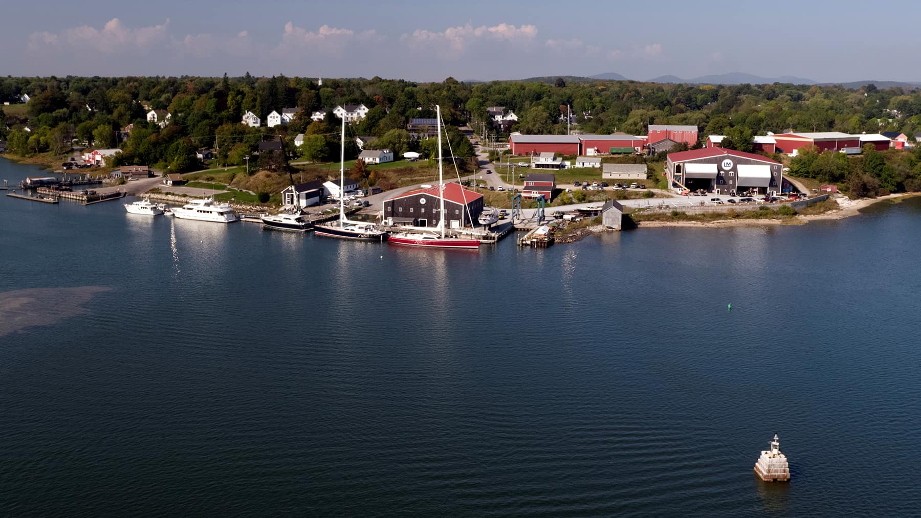
OUR REVIEWS
What CCA Members are saying:
