Mt Desert Island to Roque Island
")
The Quintessential Down East Cruise
While voyaging past Schoodic Point Lighthouse the rugged Maine coast sheds its veneer of gentrification. Beginning at Winter Harbor in Frenchman Bay off Mount Desert Island (MDI) and navigating only slightly north of east, a single week will open your boat to a treasure trove of those unique parts of this magnificent coast seldom explored by the casual summer cruiser. It is nearly fifty miles from MDI to the Roque Island Archipelago. The course is an open ocean passage with a 30% chance of fog during July and August.
Shorelines are granite with pine spiked headlands, bold and unchanged by centuries of ocean swells. Heading inland from your direct course to pause the voyage offers only a few passable anchorages and a small handful of busy working harbors chock full of lobster boats. Captains embarking on this cruise are bound to face challenges daily and will have the opportunity to hone their self-sufficiency skills in new and creative ways. Down East Maine will reward the very best efforts from all boats and their crews.
Chances are that during your coastal passage, while heading along the outer fingers of rock promontories in both directions, the navigator may experience a fair or foul tide. (Floods East, Ebbs West) Subtracting two or three knots over the ground for hours on end can make portions of the first and last days underway seem endless. The silver lining is that the dependable strong currents keep the maze of lobster traps and their toggles stretched out in a predictable pattern, and when the tide is favorable, you’ll rocket right along.
A strong cautionary tip for all skippers would be to keep a close eye on the eastern seaboard weather forecasts. Shelter is seldom ideal along this stretch and a somewhat predictable wind and sea state is essential to a stress-free adventure. This challenging passage flirts with the formidable rise and fall (up to 25 feet depending on location) of the fearsome Bay of Fundy tides, visibility issues that defy logic, and offers a dependable absence of most shore-side assistance in case of an emergency. With these sobering realities in mind, cruisers will experience a truly unique and spectacular coastline that has changed little over the last century.
Day One: MDI to Winter Harbor
Distance: 13 nm
- Approach and Cautions: This small fishing and tourist community is less than a half-day sail across Frenchman Bay from MDI. The inner harbor is home to an active lobstering fleet and there is limited but acceptable room to anchor.
- Anchorages: The Winter Harbor Yacht Club along the moderately protected outer harbor on the western shore called Grindstone Neck is a spectacular time portal to a half-century-past experience brought to life in the aging structure, style, amenities, staff, and stately launch service. Center stage for the members of WHYC is an old-style reading room with a veranda view from the porch above the harbor little changed since the 1920’s. Anchoring is possible outside of the mooring field but consult with the launch driver on access to the Club’s floats.
- Shoreside Activities: Club manager Jim Bean is a true local personality and global waterman who enjoys his job. Give his office a call (at 207-963-2346 or VHF 9) to reserve a mooring or use Dockwa. Provisioning, town events, and info on walkable shopping is contained in a handout from the launch. Lunch is served daily, and cubed ice is available.
Day Two: Winter Harbor to Mistake Harbor
Distance: 46 nm
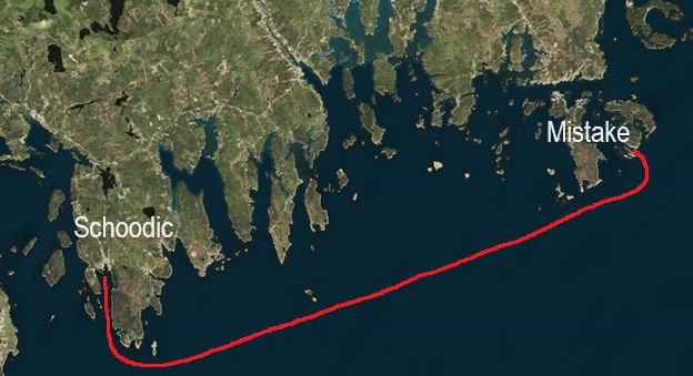
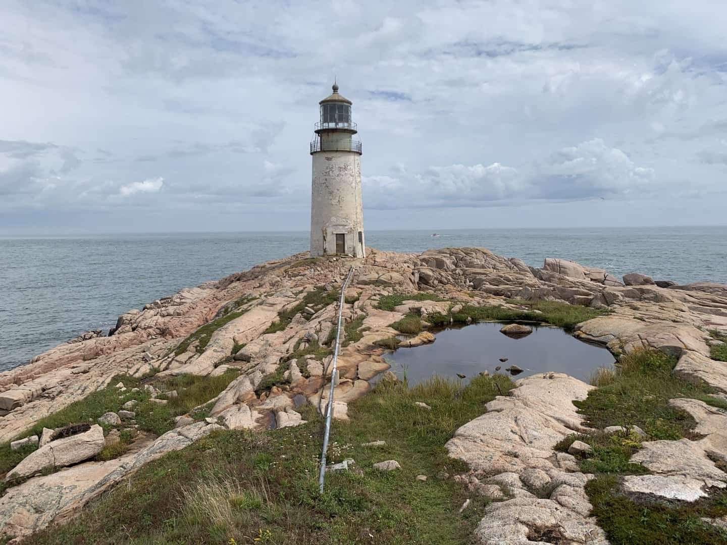
Most veteran cruisers embarking on this coastal passage try to be underway from Winter Harbor at the very first light, regardless of the state of the tide. In agreeable and stable summer weather the wind builds throughout the afternoon. Once leaving Schoodic Point behind, the lucky few enjoying good visibility will be able to line up on the tall thin spire of the Petit Manan Lighthouse to mark your course. While most will leave the lighthouse to port, the adventurous navigator, in settled conditions, may pass through the cut in the bar despite the removal of the gong and bell that marked that shortcut.
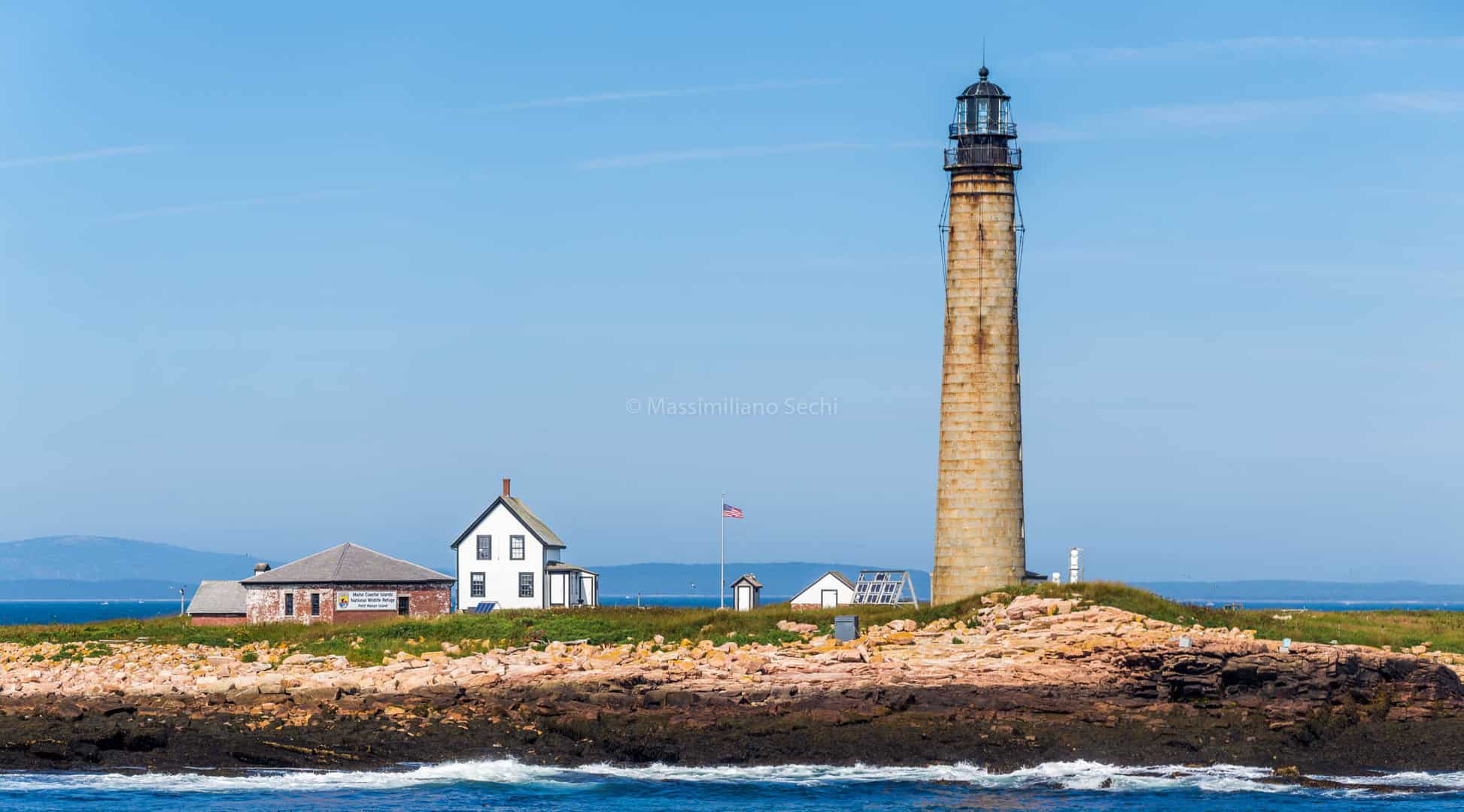
Petit Manan lighthouse photo by Massimiliano Sechi, flickr
This lighthouse milestone along the path also offers an inland detour to the Trafton Island anchorage if weather along this section of the coast turns against you either coming or going. The tenable anchorage is straightforward, and all land ashore is private.
The entire crew should practice the mandatory vigilant watch for a sea full of trap buoys and their lobsterpots to slalom around for nearly the entire day. The shortest route is along the well-trodden direct line course past Petit Manan to the Moose Peak Lighthouse, a welcome landmark and active fog signal since 1827.
- Approach and Cautions: The iconic light tower marks the entrance to the "Main Channel Way" into Jonesport. Leave the light to port and the cliffs of Steele Island to starboard. Remain in the narrow entrance until you are well past Knight Island. and come back up into the anchorage. Beware of the covered ledges near high tide.
- Anchorages: Heavy wind/weather protection increases the farther you go up into the basin between Mistake Island and Knight Island. Anchor in the charted ten-foot spot and carefully mind the mid-teen tidal rise and fall. It may become crowded with four plus boats and a nearby alternative is Head Harbor/Cow’s Yard (next harbor to the northeast--see Day 4 of itinerary).
- Shoreside Activities: The Coast Guard has an ancient and steep ramp that provides a way ashore for a couple of hours around high tide. It is an active scramble but allows access to a sloped wooden boardwalk that leads past the utility shed and out to the point where there is a wonderful scene of rocks, ocean swells and an archetypal lighthouse out of a fairybook. A large colony of seals uses the outer ledges to the west of the anchorage towards Moosabec Reach for a (loud) gathering at low tide.
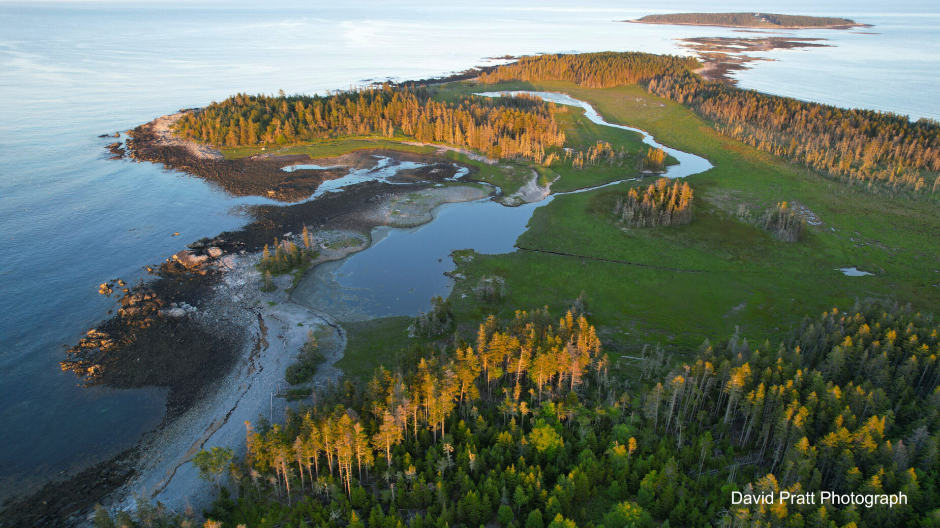
Day Three: Mistake to Roque Island (Great Beach)
Distance: 11 nm
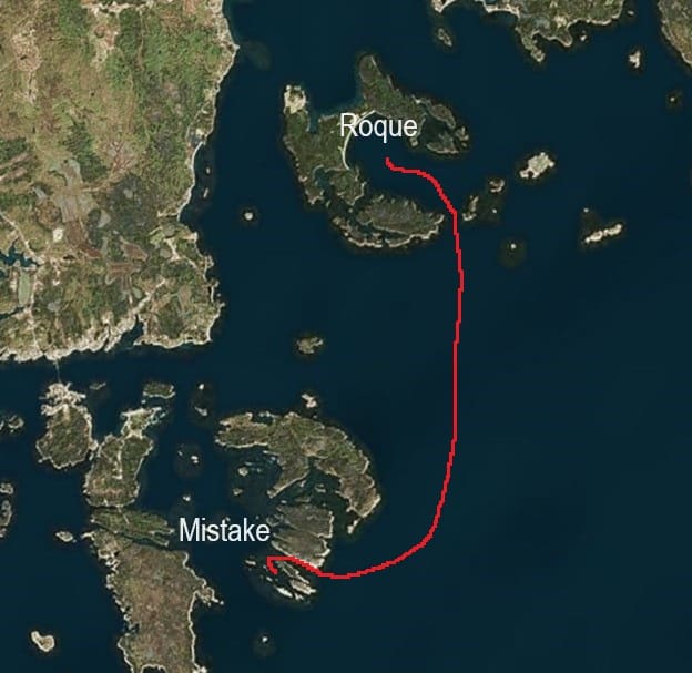
- Approach and Cautions: Leaving Mistake Harbor, turn east and run the coastline of Steele Island past Head Harbor and Black Head. Cross the mouth of Chandler Bay and approach the daisy chain of barrier islands by leaving The Black Rocks standpipe to port and approach the channel between Big Spruce and Double Shot Islands. The chart marks an eight-foot spot in the center of the narrow passage.
- Anchorages: Roque Harbor spreads out ahead with the iconic crescent white sand beach offering over a mile of anchoring opportunities. Depending on wind and wave challenges, two other semi-protected anchorages are available in the archipelago. Bunker Cove is a current swept parcel of mud and seagrass along the winding “Thorofare” leading out to Chandler Bay and Jonesport. Room here is snug for one boat. Lakeman Harbor east of Great Beach has protected room for a handful of boats.
Visitors should choose to explore the limitless possibilities for anchoring a distance down the arcing white sand to starboard for the ultimate sweet spot to drop their hook with plenty of scope and distance from any other neighboring cruisers. In the occasional strong winds that arise off the beach, north of west in these parts, the best protection is often found further to the east down past the plowed hay fields at the end of the white sand along the dense wooded high ground under Great Head. Tall pines and steep hillocks offer an effective lee.
- Shoreside Activities: Please acknowledge the island family’s long-standing generosity in allowing the yachting community to take a walk on the beach (but not beyond). This island is private land and courtesy demands everyone respect the privacy of the working farm. It is an expected courtesy to the owners to not infringe on the western most sections of the beach by anchoring off or landing near the farm’s dirt road access.
Day Four: Roque to Jonesport and Cows Yard
Distance: 15 nm
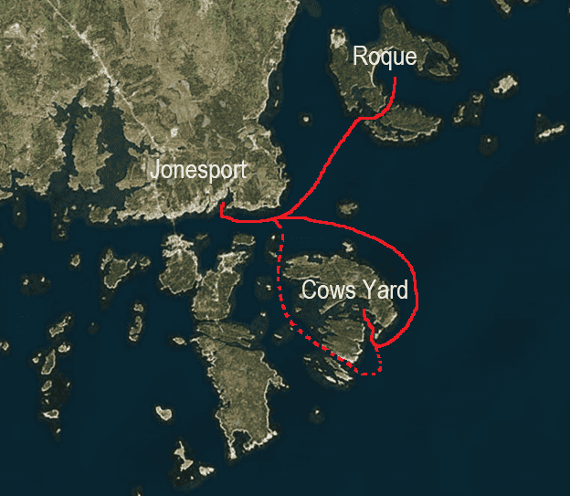
- Approach & Cautions: Leaving the Roque Island Archipelago via the Thorofare will put you on the doorstep of Moosebec Reach and Jonesport. This small town is a hardcore fishing culture with only a few resident pleasure boats. It is rightly famous for the World’s Fastest Lobster Boat Races during the Independence Day Celebration. Because of the sizeable fishing fleet, it does have significant marine/cruising support facilities although none are "at your fingertips." This is a well-protected harbor due to its substantial breakwater and is a good place to ride out an unexpected blow.
- Docking, Anchorages, or Moorings: The Jonesport Town Marina is on the west side of protected Sawyer Cove. The first set of docks, when approaching from the east along Moosabec Reach, is the town’s dockage. The docks only have 5 feet at low tide, but you can often tie alongside at mid to high. You may be able to anchor outside the moored boats in 7-9 feet at low, but be wary of mooring lines and the tight current and wind-driven swing-room limits. Trash bins are located at the head of the dock.
The Jonesport Shipyard is a rare treasure this far Down East of Schoodic and stands alone as a high quality, friendly, family-run boatyard with repair, storage, and hauling services available. The actual yard is located in the northwest corner of Sawyer Cove and run by ...
Options to Cows Yard: Once you have provisioned, the next stop on our cruise is Head Harbor Island. Behind Black Head and Head Harbor is a small, welcomed hidey-hole known as the Cows Yard. There are two routes from Jonesport. A straightforward approach involves heading out from Jonesport the way you came in, towards Mark Island back to the north and east. Once clear, run down Chandler Bay with Roque Island close-aboard to port before turning to starboard at Black Head and enter Head Harbor. The other approach option is Jonesport locals’ passage out to Moose Peak Lighthouse past Mistake Harbor and then rounding Steele Island before entering Head Harbor. This is a tidal, narrow passage with (usually) good marking and accurate depths, but don’t stray off course. The entire Moosabec Reach and the spider-web of attendant waterways off Jonesport are busy thoroughfares with lobster and fishing boats moving very quickly in all sorts of weather with their hefty advantage of hard-won local knowledge. Be especially cautious, particularly if you are new to navigating in Maine.
- Approach & Cautions: Enter Head Harbor, staying in the center between Man Island and Steele Harbor Island. Fellow CCA member Sandy Andrews adds: “With a big sea running, this may involve some surfing, so make sure your path is unobstructed – once you start in, you are committed – but the seas quickly die down once past the entrance. Be sure to avoid the rock to the left (normally breaking even at high tide) and the rock off the inner point to starboard. Both are well charted. Pass through Head Harbor and enter The Cows Yard right over the number ‘8’ shown on the chart. This is an accurate low tide depth in feet.”
- Docking, Anchorages, or Moorings: Anchor in the area where the chart shows a depth of 20 feet (there is less than 10 feet at low). To the extent you can tuck in behind the small island/reef on the eastern side of the entrance, you will be better protected, but this is not necessary in normal conditions. The anchorage shoals rapidly as you get farther in or farther east, so keep your eye on your fathometer. There is room for three or four boats max. Holding ground is good mud with some kelp. This author has never found kelp to be an issue. There are no moorings.
- Getting Ashore: All the land and the visible docks are private property. This anchorage rewards exploration by dinghy, kayak, or paddleboard. A circumnavigation of the small islands to the west is highly recommended. Sandy Andrews describes the scene: “This is a beautiful, secluded anchorage that is easily accessed and well protected in most conditions. Incredibly, one can look directly out to the ocean, but there is virtually no surge. With its many small islands, it is fun to explore by dinghy, and with its large tidal range, the scenery is ever-changing. Wildlife watching is excellent with eagles, seals, and plenty of sea ducks. The Cows Yard is one of the best anchorages on this part of the coast to ride out inclement summer weather.”
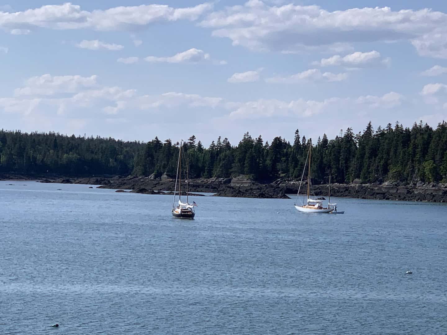
Day Five: Cows Yard to Little Cranberry Island at MDI
Distance: 48 nm
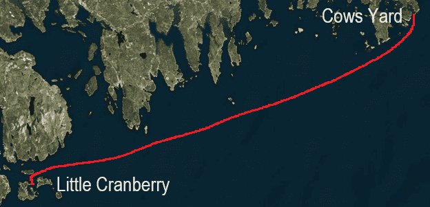
- Approach and Cautions: This is the longest passage of the cruise and has a hatful of best guess nuances guaranteed to make life difficult. Departing at first light is a gift that will keep on giving throughout the day. While it is best to try to benefit your mileage with a full six-hour fair tide, you will surely end up bucking the current for a portion of your journey. Old school wisdom is to venture farther offshore on your way west for a few good reasons. First fact is any foul tide flowing east is likely to move slower when it isn’t trying to immediately fill the hundreds of shallow long fjords inshore. The second factor is that as the wind builds it will always find its southwesterly roots. Moving at an angle offshore opens up the vector on the building afternoon breeze and waves that you will be glad are not right on your bow as you make for The Cranberry Isles. One final note is to always consider seriously the wisdom of turning around and going back to try another day. This is a potentially dangerous section of coastline and should not be underestimated.
Approaching the Cranberries from Down East, it is easy to head for the north shore of Little Cranberry Island, being sure to stay easterly of the string of four green cans to the east of Baker Island and Little Cranberry. When you sail into Little Cranberry from the channel, be sure to respect cans 1, 3, and 5 to port on your approach.
- Docking, Anchorages, or Moorings: At Little Cranberry there are three town moorings for guests and private moorings marked as being for rent with phone numbers on them. There is also comfortable anchoring with good holding and ample swinging room outside the mooring field off Little Cranberry Island docks.
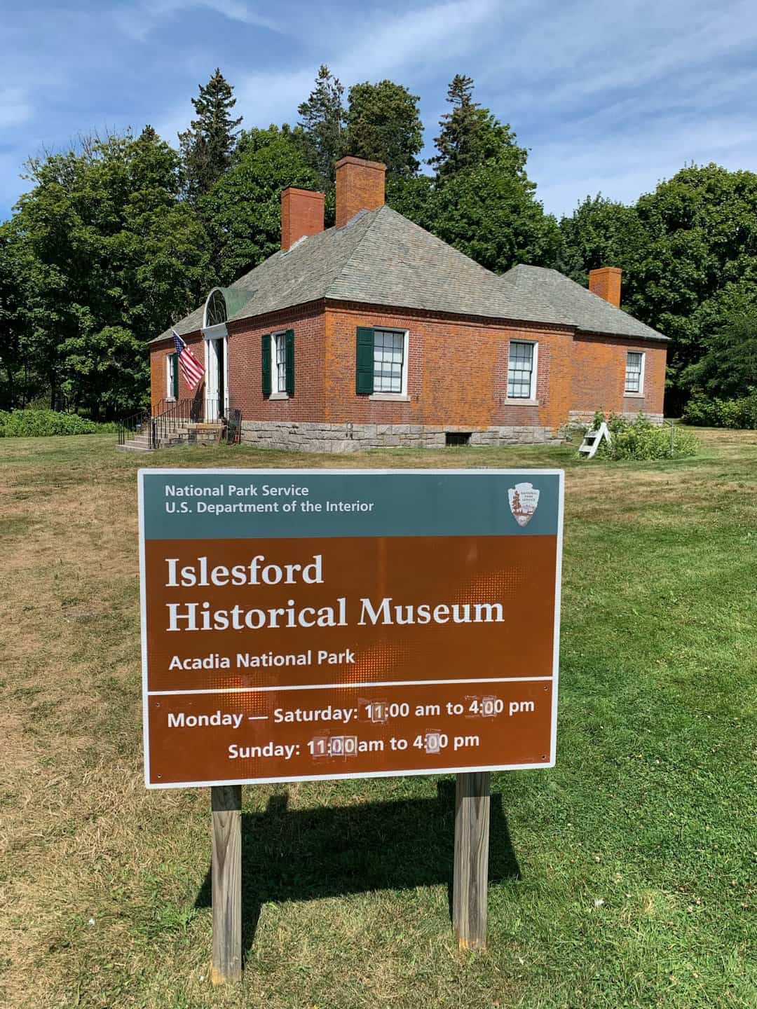
- Getting Ashore: Little Cranberry Island is well known for its array of things to do that appeal to visitors. Within a quarter mile of the Islesford Dock Restaurant dock, one can find Acadia National Park’s Islesford Museum and the nonprofit wooden boatbuilding school teaching traditional skills, Islesford Boatworks. There are two art galleries on the Restaurant Dock, a pottery shop and a gift shop. The Ashley Bryan Pavilion showing the artwork of a highly respected island artist, and the Islesford Artists Gallery are both nearby.
On nearby Great Cranberry, there is the Preble-Marr Historical Museum, which is in the same building as Hitty’s Cafe. It provides an interesting perspective on the evolution of the island’s community. Great Cranberry also has two nice hikes. One starts along the main road to the left of the tennis court and goes to Preble Cove on the Western Way, which has a lovely beach. Farther up the main road, a Maine Coast Heritage Trust trail goes through the woods out to the outer south shore. The Cranberry Shuttle can both take folks to the trailheads and pick them up later. You can also take one of the ferries over to Mt. Desert Island and easily access the trail network of Acadia National Park using the L.L. Bean shuttle service.
This ambitious itinerary opens the cruising boat and her skipper to topography, weather, and navigational challenges seldom experienced by New England sailors, but the reward is unmatched natural beauty and an adventure second to none. For some it is a rite of passage allowing one to say (boast) that you've truly experienced the coast of Maine.