Photo:Ram Island Light at Damariscotta River entrance - by Paul VanDerWerf
Described by many as one of Maine’s most scenic estuaries, the Damariscotta River is also a place of peaceful beauty, especially on a day with foggy or stormy conditions on the ocean just outside. It has also gained notoriety for high quality oysters with many oyster aquaculture farm operations in the upper reaches.
As one approaches the Damariscotta River, it becomes evident that Massachusetts, New Hampshire, and the southwestern coast of Maine have all been left behind. The scenery and general conditions are more typical of what lies farther east. While there are some rocks and ledges along the way, with careful attention and planning, there should be no problem navigating in these waters.
Extending just over 14 miles from the river entrance to the town dock in Damariscotta, the river changes character several times, progressing inland through narrows, open vistas, and steep-to shores, becoming more peaceful farther inland and generally calm above Glidden Ledge. On a thick day outside, it may scale up to be sunny and warm by north of Fort Island, only a few miles inland. A dip in Seal Cove will likely be brisk, but the water is warm farther inland, and a real swim can be a pleasure at Dodge Point.
Approach & Cautions
Photo: Pemaquid Point Lighthouse at sunrise by Andy Thrasher
From the south – A quick introduction to scenic Maine and some of the hazards off Damariscove Island will be apparent. Bantum Rock breaks in almost any sea. It marks the entrance to Damariscove Island – an intriguing harbor itself and highlighted in a separate entry on this website. Though the prevailing SW wind may be blowing into the anchorage, the underwater land configuration attenuates the seas to a remarkable degree giving a calm anchorage. Leaving the ledges of Outer Heron and the White Islands to starboard, make sure to leave the day marker (RW H), just south of the Hypocrite Islands, to port and then on to the mid-channel RW Buoy “HL,” bringing the entrance to the river into View.
From the west – Passing Seguin, the Cuckolds, and Boothbay to Fisherman’s Passage, the ledges are well marked and should be no problem even in thick weather with a sharp lookout.
From the East – Pemaquid Point Light stands as the entrance to the Damariscotta area. Make sure to honor R2, and in heavy weather, to stand off outside and below the GRC “PL” can to the south to avoid seas that build on those ledges. Weather permitting, head NW through outer Johns Bay to the “Thread of Life,” south of Shipley Point and Christmas Cove. While the chart may make you think twice, this is not to be missed – being narrow but deep. A weatherly boat can short tack through. If coming from well outside, you may choose to enter by passing Thrumcap Island and enter leaving Inner Heron Island and N2 to starboard.
Little River – An inlet near the mouth of the Damariscotta, access is limited to settled weather and moderate size boats. The anchorage is tight, with 10-15 feet at low and 5 feet at the dock. There are no moorings, only short-term dockage. Lobster may be available, but not much else. However, if you are gunkholing, it is a pretty 30-45 minute tour.
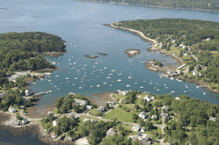
Christmas Cove – Captain John Smith dropped anchor in a beautiful, protected cove on Christmas day in 1614 and aptly named it Christmas Cove. Today the cove abounds with summer activity and is home to many types of boats, both sail and power.
The approach to Christmas Cove is reasonably straightforward. Leaving Foster Point to port, stay in the middle of the channel. Proceed toward the two daybeacons which mark the ledges that protect the cove. Red day beacon #2 will be on your right; however, be careful as a ledge extends 50 feet out into the entrance. Green daybeacon #2 marks the edge of the shoal water to port. Pass about halfway between the two marks and you will enter the inner mooring field.
Christmas Cove is home to the Christmas Cove Improvement Association. Founded in 1900, the CCIA operates a summer program for children with sailing, swimming and tennis lessons as well as holding regattas for all day sailors, including the Christmas Cove 21, the club’s one design. The club also provides a family-oriented social center. It’s located to the east as you enter the cove.
Coveside Marina and Restaurant (207 644 8282), on the northwest side of the cove, is the prominent landmark ashore. A very popular restaurant offering great seafood as well as a traditional menu, it has waterfront dining, both inside and out. Enjoy The Burgee Bar with its great Dark & Stormy and live entertainment Friday and Saturday nights. On Sundays, their deck party with live music and dancing is not to be missed! Check their website for the latest menu and hours. Coveside moorings and slips are available on Dockwa. Ice and some supplies are available.
An aerial view of Christmas Cove. Photo by Patrick Moran, King Pine Aerial
East Boothbay – Ocean Point Marina (207-633-0773) has deep water on the approach and 15 feet alongside. While usually calm here, there may be wakes from river traffic, and a swell can make in when a sea is running from the south on the outside. The tide is quite strong here and will frequently cause the boat to rest contrary to the wind direction. Fuel, water, moorings, dockage, ships store are all available. We recommend calling ahead. Hodgdon Yachts and Washburn & Doughty boatyards are adjacent, but do not provide chandlery services. All manner of interesting vessels may be on their rails. Hodgdon was recently well known for building magnificent mega sailing yachts but have moved operations elsewhere in the area and now focus on making luxury megayacht launches. Washburn & Doughty is known for making hi-tech tugs and ferries.
South Bristol – The Gut is a narrow protected harbor that runs from the Damariscotta River to Johns Bay, separating Rutherford Island from the mainland. South Bristol has a busy lobstering and fishing fleet, some of which operate year-round. All of the moorings are dedicated to the commercial fleet and are not available to visiting cruisers. As you enter from the Damariscotta River the historic Gamage Shipyard (207 644 8181) is on your left, directly across from East Boothbay on the east side of the river at Bristol Gut. It has a reported depth of 10 feet; they offer some transient dock space and moorings, fuel and water, a lounge, wifi, laundry & showers, plus a travel lift, repairs, and can be available on call. Hail them on 9 or 68, or call ahead.
There’s also a small grocery in the village. Proceeding through the bascule bridge leave the red day beacon “2” well to starboard and as you approach the bridge give wide berth to day beacon “3”. The bridge opens on call 24 hours a day and can be reached on channel 9. The water depth is 4 feet at mean low tide and the current can be significant and varies based on the tide. The overhead power cables have been raised and are now reported to be 70 feet above high water. Passing through the bridge stay in the middle of the channel as there is a three-foot ledge protruding from the south side just below the water at low tide.
Entering the Gut, Osiers Wharf (207-644-8101) is on the north side offering gas and diesel, plus beer, ice, wine, groceries and some marine supplies. They are a convenience store/deli and serve food all day, closing at 6:00 pm.
Bittersweet Landing Boatyard (207-644-8731) is a full-service boatyard and services diesel, gas and outboard motors. They have 5 moorings and possible slips available with Wi-Fi; it is best to call ahead.
South Bristol Fisherman’s Co-op (207-644-8224) is on the north side of the Gut and sells both gas and diesel 7 days per week. They sell live and cooked lobsters and clams, marine supplies and have picnic tables overlooking the harbor. Open 8:00 am to 6:00 pm daily.
Entering or exiting from the Johns Bay side is straightforward–however–staying between the red nun “2”at McFarlands Ledge and green can “1” at Corvette Ledge is important.
See Anchorages below and More Harbors Upriver at bottom of page
East Boothbay – Relatively deep in Meadow Cove. See notes re: Ocean Point for general conditions.
Fort Island – Minding the Western Ledges, the anchorage behind Fort Island reportedly has good holding and is sheltered in a northerly. It used to be refuge while waiting for fair current in the narrows.
Seal Cove – While there may be hundreds of Seal Coves in Maine, this is still a hidden gem with almost no indication of civilization once inside, until you go deep in the cove. Cell service may be weak or absent depending on your provider; AT&T users generally have more issues than others in the area in general. There is good holding in mud anywhere in the middle carrying 20 feet at low. A dinghy cruise around Hodgson’s Island or the unnamed island to the east is always a hit – check the tides, as the passages can be very thin or even dry out at low. Or continue deep into the cove over the 5-foot bar to the inner harbor to anchor in 12- 15 feet — although there are now quite a few houses, and it doesn’t feel as secluded as outside the bar. Well named, seals are often seen here, especially on the ledges in the inner harbor.
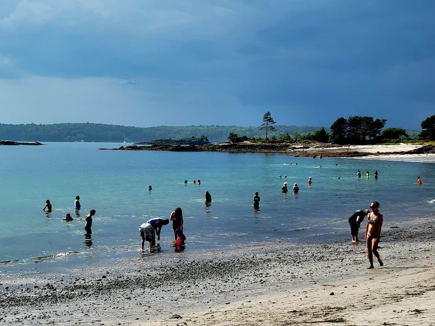
Johns Bay, “next door” to the Damariscotta River, offers three options for an overnight stay: Pemaquid Harbor, the South Bristol Gut behind Witch Island and the East Branch of the John’s River. Also, the best beach east of Reid State Park on Georgetown Island, near Seguin (which is hard to access while cruising) and west of Penobscot Bay, is Pemaquid Beach, easily accessible by foot from Pemaquid Harbor. It has good facilities with male and female changing and shower areas, chair/parasol rentals and a very good snack bar. It’s an option for those with members of the crew who like those alternative activities or who have to entertain young “future sailors.” (Watch out for the seagulls. They have no compunction in stealing a perfectly good and uneaten sandwich right out of your hand!)
People enjoying the shallow water at Pemaquid Beach. Photo by Ed White
See More Anchorages Upriver at bottom of page
General Navigation Tips [Followed by MORE Harbors & Anchorages]
The river entrance is wide open in any weather and runs deep to the Narrows at Fort Island. The approach is subject to strong tidal currents that can create whirlpools and magnify conflicting boat wakes. On occasion the current is strong enough to drag the C11 can or N12 nun underwater, so favor the Fort Island side of the marked channel heading north.
After the Narrows the river widens, and the course is up the middle, passing the entrances to anchorages in Seal Cove and Long Cove. Line up the center of Miller Island and Carlisle Island as the ledges on their south ends make out a bit. There are many pot buoys in this stretch, sometimes tangled in a group by the swirling current, but staying in the center yields a thinner density field as opposed to the west side.
Passing Pleasant Cove to the west be aware of the long string of ledges submerged at high tide, leading out to C13. Pass the Darling Marine Research pier to the east and head directly towards N14, leaving it some room to the west, as the shallows are south of the mark. Round the spindle (G) and Merry Island to port and stay on the west side of the channel approaching the Glidden Point spindle (R) from the SW. Glidden Ledge is covered at high water and runs across from the eastern shore; give the day marker R16 a bit of room. The channel is deep; however, the current runs hard through this narrows, with whirlpools for the next quarter mile north. Above Glidden Point are many oyster farms with boundaries marked with yellow buoys. Dodge Point on the west side has a dock for access to the preserve there.
After Perkins Point spindle (G19), the channel narrows and requires close attention to your GPS or at least depth finder. Note, you cannot run directly from mark C17 to R20 because the channel is “S” shaped with a mud flat extending 100 yards south of R20. There is a safe passage all the way to Damariscotta village. At mid-tide and lower, the water is very shoal (exposed mud on a moon tide) to the west side of the channel just southwest of C21 and west of C23. This area is also heavily populated with oyster farm cages.
More Harbors Near Top of Damariscotta River
Damariscotta and Newcastle – At the head of navigation, the channel is narrow above Hall Point (also known locally as Cottage Point) up to N24. The current runs hard past the mooring field, so this would be a problematic anchorage. If you are planning to anchor, it is best to stay opposite Hall Point. Riverside Boat Co. on the west shore, the Newcastle side, (207-563-3398) lends moorings–please call ahead. The harbor master is Eric Peters (cell: 207-380-8158). For larger vessels, one large mooring may be available near Hall Point; you may inquire with the owner by email at [email protected]. There is a town dinghy basin on the east side (Damariscotta side). It has outside floats reporting 5 feet at low and a two-hour limit. No fuel is sold here; however, a gas station is less than 50 yards walk across the town parking lot. Schooner Landing Restaurant on the river burned last year, but they hope to reopen as a food truck for the summer while they rebuild (207-563-7447). The town offers numerous services and pleasant cafés, restaurants, quality gift shops, and a few galleries for this size village. In Damariscotta, there is a large Hannaford, approximately 1.5 miles east with Rising Tide Co-Op organic foods and other groceries choices, Main Street Grocery (IGA), as well as a Walgreens, about 0.5 miles west. Damariscotta Hardware, and a NAPA halfway between these and the Hannaford. In town, there is a laundromat across Main Street, a Reny’s (“♪A Maine Adventure!♪”–clothing, food, camping equipment, toys and and a slew of other “necessities”), kayak rentals, river tours, etc. Beal House, a gourmet shop at 72 Courtyard Street, has fresh baked goods, wines & beers and women’s clothing; plus the Riverside Butcher Co. and Simmons Seafood are both first-rate.
For urgent healthcare needs, seek out LincolnHealth Miles (Hospital) Campus. 35 Miles St., Damariscotta, Phone: 207-563-1234. There is a 24-hour physician-staffed emergency department.
More Anchorages Upriver
Moving up the river past Carlisle and Miller Islands, there are several possibilities for anchoring. Between Carlisle Island and the shore, the bottom is rocky, so using a tripline is advised. Take care not to find the rock at the south end of the island or the shallows off the mainland.
Clark Cove – This is a more open anchorage on the eastern shore — good for settled weather.
The mid-river above Miller Island has several possible anchorages from long and narrow and deep to some a little more than a scallop in the shoreline.
Pleasant Cove – Scenic at high tide and open to the east, this changes character as the tide recedes, with large areas of flats. It offers good protection from all winds when anchored deep in the cove.
Wadsworth Cove – Past can #13, there is good mud and protection from Carlisle Point to the south.
Darling Marine Center, Wentworth Point – Managed by the University of Southern Maine dmc.masine.edu, 207-563-3146, Call for possible moorings and current programs.
Salt Marsh Cove – While the inner cove dries out, there is thick mud at the 13-foot spot.
Mears Cove – Snug in NE corner and reputed to be the best holding and out of the current.
Fitch Cove – Above Glidden Ledge, there’s reportedly good holding in mud on the eastern shore near Brick Hill Rd. Shore access may be available to the oyster farm near here.
Dodge Point – South of the point anchor in 12-14 feet with good mud. There’s access to Dodge Point Park and several trails – a nice walk in the woods or running path. The park provides a pier and float for landing a dinghy.
Hall Point – good views and good dingy access to town, Bald Eagles on Hog Island will be soaring, and an easy dingy ride back to Dodge Point too. Note: there is a big mud flat that extends SW from the southern C21 all the way up to the west side of C23.