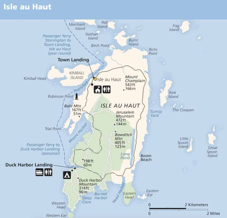
Isle au Haut is Maine at its archetypal best. It is one of several offshore islands supporting year-round communities, home to fewer than 100 year-round residents. It is also the remote wing of Acadia National Park available only to visitors willing to take a boat ride, either their own or one of two ferries running regular routes. One ferry is the regular mail boat that operates year-round, and the second is run by the park service seasonally. Hiking trails are beautifully maintained by the park service and cover most of the island’s 8000 acres boasting spectacular views of the easternmost end of Penobscot Bay. A couple of good anchorages and a few guest moorings are available first-come-first-serve at Point Lookout (aka Laundry Cove), on the island’s north end, and in the Isle au Haut Thorofare located just off the village.
Isle au Haut
Last edited by:
- Nat Warren-White
- March 29, 2022
- 4:25 pm
- 0 comments
Region:
Photo: Sunset view from Point Lookout to Camden Hills by Nat Warren-White
Approach & Cautions
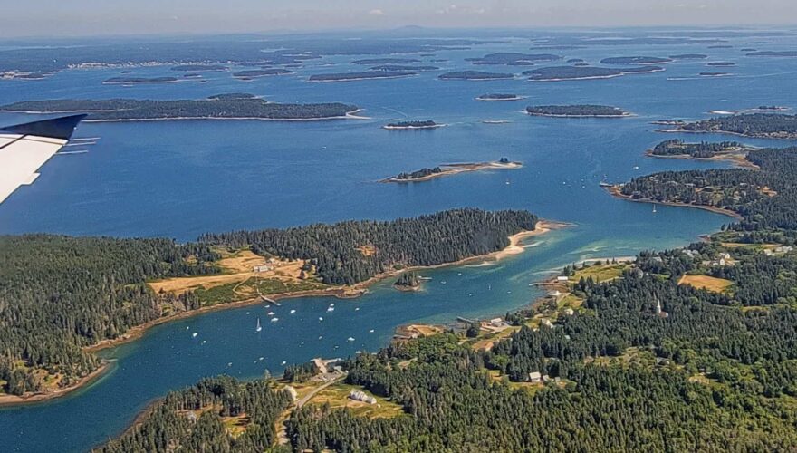
Photo: Aerial by Dale Bruce with Frank & Libby Simon, pilots
The approaches are open and accessible from the west across East Penobscot Bay with a straight shot from the Fox Island Thorofare and from the north, a scenic cruise out from Stonington, the nearest large town and shopping mecca. From the east, it’s an easy shot across Jericho Bay from Swan’s Island or Mt Desert. From seaward, it’s an open water 15-mile run in from Matinicus. Navigation markers are well-positioned and easy to find. CAUTION: The only spot to watch out for is in the Thorofare channel, less than 6 feet deep at low water. It’s best to pass through here on a rising tide and beware of the several rocks just outside the narrow channel. Stick close to the channel markers, and you’ll be fine.
Docking, Anchorages, or Moorings
Three guest moorings are available in the Thorofare and two off the Point Lookout landing, also known as Laundry Cove. You can drop passengers off at the town landing, but you may not leave your boat there for any length of time as it serves as the ferry landing and the working dock for the local fishing boats. We like to anchor or pick up one of two complimentary guest moorings off Point Lookout (where the view toward the Camden Hills from behind Flake Island is unbeatable) and take the dinghy through the Thorofare to the town dock. From here, it’s a short walk to the village store, post office, church, and library. The town also owns three rental guest moorings just off the town dock, but it’s much busier here than off Point Lookout. The dock at Point Lookout is private, owned by the Point Lookout Association, but you can tie your dinghy here and take the long walk to town along several dirt roads that take you past the one-room schoolhouse, the community center, and the white-steepled church. There are no amenities here — no marinas, water, fuel, or pump-out is available. There is a small store where you can buy ice and a few groceries.
Getting Ashore
Photo: Town Landing in the Thorofare - courtesy Points East Magazine
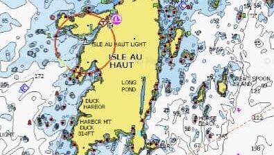
You can land your dinghy at the Point Lookout dock, at the town dock in the Thorofare, or at the pier off the store and post office, which is much less accessible at lower tides. The local general store has a reasonable selection, and there is a great food truck open for lunch during the summer months. The Keeper’s House Inn, located at the lighthouse on the south end of the Thorofare, may or may not be open for dinner. Otherwise, the only other restaurants are in Stonington, a 6-mile run to the north through the gorgeous Merchants Row islands. Hikes: Exploring this island from one end to the other is a delight. There are several mountains, which is how the island gets its name, “High Island,” dubbed so by French explorer Samuel de Champlain. The tallest peak, Champlain, at 543 feet elevation, is followed by Jerusalem Mtn @ 472’, Bowditch Mtn @ 405’, Duck Harbor Mtn @ 314’, and Bald @ 167’. There are hiking trails that will take you to these high spots and Long Lake, a gorgeous chilly freshwater swimming spot. Other spectacular viewpoints include Eastern and Western Heads, Boom Beach on the east side, and Point Lookout on the northwest corner, offering a lovely sunset look back at the Camden Hills. See the map below showing roads and hiking trails throughout the island.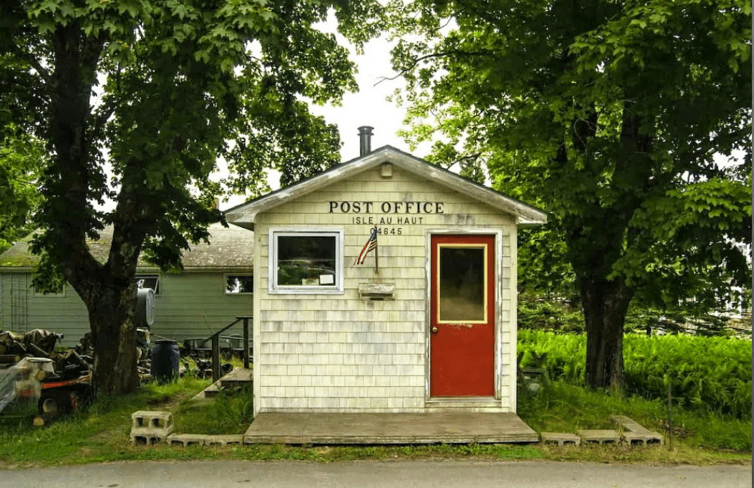

Other Things To Do: Exploring to your heart’s content. Walk up to the Island Church (near the town landing). It is an impressive building in a beautiful setting. Occasionally there are wonderful village celebrations such as the unbeatable July 4th Parade and sometimes a Friday or Saturday night dance and musical party at the community center. Other Nearby Anchorages: Duck Harbor (SW side of Isle au Haut), Moores Harbor at IaH, Devil & Bold Islands, Round Island, McGlathery Island
OUR REVIEWS
What CCA Members are saying:
Isle au Haut is one of our favorite cruising stops on the Maine coast. We’ve spent many a memorable anniversary moored behind Flake Island, digging steamers and toasting the sunset. Can’t be beat!
Nat Warren-White
Perhaps because of its remote location; perhaps because of its rugged mountainous topography; perhaps because it takes extra effort to get there, Isle au Haut has always captured our imaginations and our desire to explore. It is indeed a very special place.

Doug Bruce