Quahog Bay & Snow Island

Last edited by:

Photo: Courtesy of The Portland Press Herald

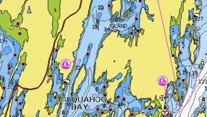
Surrounded on three sides by the sprawling coastal town of Harpswell, Quahog Bay captures the authentic charm of mid-coast Maine. Depending on the moon's phase, 7- to 12-foot tides sweep cold, nutrient-rich waters in from the open Atlantic. This ebb and flow sustains a vital and productive marine habitat that is home to a diverse array of fish, seabirds, and shellfish.

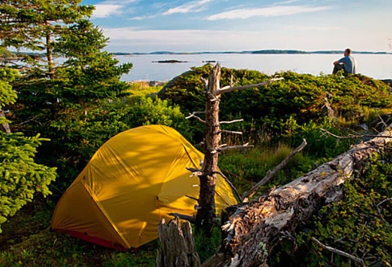
For many generations, Quahog Bay's waters have provided a living for commercial fishers and their families. The bay has also attracted recreational boaters and outdoor enthusiasts, all of whom enjoy its beauty. While several attractive anchorages can be found within this expansive bay, Snow Island offers the best protection.

Approach & Cautions

Photo: Meg Coon

There is one tricky aspect of approaching from the west. When passing Red Nun “8” at Gun Point/Oak Island, it is best to go east through the deeper channel that lies 1/8th nm south of the nun rather than pass close to it. There are shallows on either side of the channel, so it is best to keep a close watch on the chart plotter as you pass through. Once past this point, the approach to the anchorage is well marked, and the channel is deep so long as you pay attention to the ledges that run north-south on either end of Pole Island, which can be passed on either side.

Approaching from the east also involves one tricky, narrow spot that requires attention to the chart plotter. The approach will take you up the outer New Meadows River to the east of Yarmouth Island and thence through a narrow passage between Yarmouth Island and Sebasgodegan. This is a small anchorage, so you may have to weave through a few moored boats while steering clear of the 3-foot spot on the south side of the channel. Once through, you will travel through the channel on the east side of Pole Island.

Click the chart to open Navionics.

Not to be used for Navigation.

Docking, Anchorages, or Moorings

It is possible to anchor anywhere near Snow Island, though the most popular spots are to the south and east of the island.  Depths are 8 to 18 feet at low, and holding is good in mud. The anchorage is well-protected from wind in any direction, and boat traffic is light.

Amenities:

The anchorage around Snow is quiet and “no frills.”  But if you have an emergency boat need, Safe Harbor Great Island Marina lies ¾ nm north of Snow Island. This is a capable, full-service marina with water, fuel and a waterside restaurant.

The Quahog Bay Conservancy, an organization dedicated to maintaining the environment of the Bay, offers a free on-call pump-out service for anyone anchored in the area by calling or texting (207) 522-1105 weekdays 0800-1500 and sporadically on weekends.

Getting Ashore

Photo: Maine Island Trail Association

It is possible to get ashore on Snow Island, Center Island to the west of Snow, or any of the unnamed islands to the east of Snow for a bit of beachcombing.

Provisioning:

In a pinch, and if you can arrange transportation, the Safe Harbor Marina lies only 6 miles from the Cook’s Corner area of Brunswick, where you will find a Hannaford Supermarket and a Walmart.

Dine Out:

Iris Eats is a breakfast and shop co-located with the Safe Harbor Great Island Marina.

Hikes:

There are no hikes nearby accessible without transportation.

Other Things To Do:

Again, if you can arrange transportation from Safe Harbor, Brunswick, 10 miles distant, is the home of Bowdoin College and several attractions:

The anchorage is also an ideal spot for a quiet morning row or paddle board around the islands to the east of Snow Island.

Information on camping on certain islands is available from Maine Island Trust

OUR REVIEWS

What CCA Members are saying:

Snow Island in upper Quahog Bay is a hidden gem, where the swimming can be enjoyed on a warm sunny day.

Doug Bruce

Got some feedback or notes for this page?

Send us your input.

Subscribe to our newsletter for updates your inbox

Name